The rhythm of the North Fork flows to a mellow tempo, even as the steady thrum of traffic and the ever-present flotilla of rafts and kayaks sketch a clear portrait of the wild and scenic river corridor’s growth and popularity.
Dust clouds roll off this unpaved portion of Highway 486, also known as the North Fork Flathead Road, and the meter of traffic ticking along the western border of Glacier National Park has given rise to the need for a new river management plan.
Designated a National Wild and Scenic River in 1976, the three forks of the Flathead River amount to 219 miles of what everyone agrees is “a very special place,” says Rob Davies, the Flathead National Forest’s district ranger for the Hungry Horse/Glacier View district. The North Fork Flathead River is protected by that designation, while its eastern tributaries and uplands are tucked away in Glacier Park. Its Canadian headwaters are protected by a provincial ban on mining and drilling, and U.S. Sen. Max Baucus has introduced legislation that would prohibit new energy and mineral development on the nearly 400,000 acres of the North Fork watershed within the Flathead National Forest.
Still, public land managers say the river corridor is being impacted by increased use, and have been collecting data to inform the future of the river corridor, while calling on the public to help adopt a new management strategy for recreational use.
“There is the perception that day use is increasing on all three forks of the Flathead River, and we are trying to validate whether that is actually happening through surveys, monitoring and data collection,” Davies said.
National experts in wild and scenic river corridor management have helped officials the Flathead National Forest and the National Park Service strategize about how to move forward, Davies said, and both agencies are collaborating on the new management plan.
“It has a really high value. There are very few wild and scenic designations in Montana, and we need to be respectful and take care of this resource,” he said.
Recently, land managers from both agencies embarked on a float trip on the North Fork to discuss the perceived increase in use by hikers, campers and boaters, which has created issues with human waste, dispersed camping and conflicts with wildlife.
Scott Emmerich, Glacier National Park’s longtime North Fork District Ranger, has observed traffic and visitation increase for the past decade, and said the parking lot at the Bowman Lake Campground just inside the park can barely accommodate all of the cars, trucks and trailers.
The conversation about designing a new river management plan is critical in order to mitigate associated impacts to the corridor, he said, and the public’s input will be an important element.
“We are seeking input on how to protect this wonderful resource, this river that is starting to get used to death,” he said. “But the good thing is that we are talking about how to protect the solitude of the river and preserve all of the qualities that cause us to enjoy it.”
In recent years, more than 40 miles of the unpaved and dusty North Fork road have been treated with magnesium chloride through a cost-shared dust-abatement program between the county and North Fork residents. Emmerich speculated that improvements to the road, the primitive nature of which has served as a sort of governor for visitors, could be responsible for the increase in visitation.
“If you build it they will come, and if you improve and make it easier to get here they will come,” he said. “It’s a dance you do and it is a challenge. And I don’t know if we can take a step backward.”
Denise Germann, public information officer at Glacier National Park, said a grant last year allowed the park to launch the “Flathead Wild and Scenic River Corridor Stewardship Project,” which funded the purchase of gear designed to minimize visitors’ impacts on the environment.
 |
|
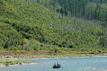
People fly fish from a boat as they float methodically down the North Fork Flathead River. – Lido Vizzutti | Flathead Beacon |
Through the grant, the park purchased several hundred biodegradable, puncture-resistant human waste bags, five fire pans, and eight bear-resistant coolers. Park visitors floating the North and Middle forks of the Flathead River can check out the equipment at the Apgar Backcountry Permit Office free of charge.
“We are working very closely alongside the park to ensure that our management strategies are consistent and in sync with each other,” Davies said.
When Congress designated the Flathead a National Wild and Scenic River in 1976, land managers were charged with drafting a management plan under the National Wild and Scenic Rivers Act. Although that plan still exists, Davies said it is in need of updating.
“We don’t have a lot of hard data right now but our river rangers have been monitoring the corridor for the past two years as more of a social study to see how many floaters we are seeing each day,” Davies said.
Adding to the perception that river use is growing is that new user groups are cropping up – in addition to rafters and kayakers, more people are using stand-up paddleboards, for example, while many others are hiking and camping, Davies said.
“Through the study, we are trying to examine user groups other than river floaters because people are coming to fish, swim, hike and camp,” Davies said. “We are trying to take a comprehensive look at all use on the river and address everything that is happening, whereas the old plan only addressed floaters.”
On the North Fork, the management boundary between the U.S. Forest Service and the National Park Service is drawn down the middle of the river, while on the Middle Fork it is designated by the high-water mark. The South Fork Flathead River is entirely managed by the Flathead National Forest, Davies said, but co-managing the other two-thirds of the watershed requires careful planning.
Flathead National Forest officials will reconvene with Glacier Park managers in the fall, Davies said, and at that point will have a better idea of the timing and scope of the new management plan.
Some popular rivers that have seen increased use, such as the Smith River, have adopted a permit system in order to control use by floaters. Both Emmerich and Davies said they hope that won’t be necessary in the Flathead River, but that better information about visitor use will be an important component when drafting the new management plan.
“We need to know what the current use looks like, understand the current resource impacts, and follow the trends to potentially set capacity points or trigger points that may lead to stricter policies,” Davies said. “Right now we are nowhere near the point where we would need to implement a permitting system.”